|
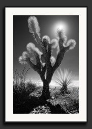
Ahh.... the desert. Dry dusty air that just sucks the moisture right out of you, prickly and dangerously sharp vegetation, relentless sunlight beating down. Maybe it's all of the rainy days endured growing up in coastal B.C., but for me, it is one of those things that I just can't get enough of. I truly love being out in the desert, the solitude, the exotic plants and animals and the spectacular wind and water eroded rock formations. Driving through the Mojave desert on the way ot Las Vegas, I decided to take a side trip off the interstate and hit a dirt road. A few kilometres and I was away from the traffic and alone in the desert, hiking a couple of km from my truck and taking infrared photos of yuccas and Joshua trees. Apart from some powerlines in the distance and an old rusted hulk of a station wagon in a dry wash, it felt like I was out in the middle of nowhere. |
|
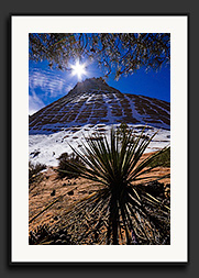
Gallery: 2007 / Zion National Park, UT Zion National Park... deep canyons carved into immense majestic red sandstone formations and the free flowing waters of the Virgin River, sustaining incredibly lush vegetation for such a hot and dry desert envirnoment - these contrasts are what distinguish Zion from other southwest desert parks. This early in the year though, the trees are still bare and the vegetation is still dormant after a fairly cold and dry winter. This park will be in its finest form later in the year when all the lush greenery is back in its full glory. It was interesting to see now, but if there had been more than a mere dusting of snow on the bluffs, it could have been far more photogenic than it was. I picked up Carol Polloni, my friend and manager of Beau Photo, in Las Vegas and we made our way to Zion National Park that evening. We then spent two days in Zion before heading out to Bryce Canyon. |
|
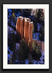
Gallery: 2007 / Bryce Canyon National Park, UT The Native American Paiute tribe called the Bryce Canyon badlands Unka-timpe-wa-wince-pock-ich which translates to "red rocks standing like men in a bowl shaped recess." Ebenezer Bryce (for whom the park was named), had tried to farm in the Bryce amphitheater in the late 1800s and declared that it was "a hell of a place to lose a cow!" Two apt descriptions of the topography in this amazing park. The Bryce Canyon amphitheater contains a staggering array of spindly sandstone formations in just about every pastel colour imaginable. Some of these spires are hundreds of feet tall, and many hiking trails wind through this surreal landscape. There are numerous panoramic views from the canyon rim which is over 8000 feet high! Carol and I spent a couple of days here hiking around before heading back to Las Vegas for the PMA Trade Show. |
|
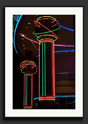
Gallery: 2007 / Las Vegas, NV Prepare to be overwhelmed by the gaudy and over-the-top display of neon and kitsch which defines Las Vegas! The evening that Carol and I arrrived in Vegas, we visited and photographed several hotels, including New York New York, The Luxor and Excalibur. Many of the photos in the gallery were taken at "The Fremont Street Experience", where there is a huge dome covering several entire blocks of Fremont Street. This dome houses an enormous number of RGB lamps which are all controlled to display huge moving image light-shows, every hour on the hour in the evening. We watched three different shows, the first being a big "advertisement" for LG Electronics who seems to be sponsering a big part of the Fremont Street show. The second was a none-too-subtle US patriotic show and the last was an "adult" show with scantily clad women singing and dancing their way across the huge domed ceiling. |
|
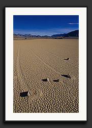
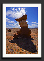
Gallery: 2007 / Death Valley, CA After dropping Carol off at the Las Vegas airport, I rendezvoused with my friend Ted Marshall, who used to work for Beau Photo and was down attending the PMA trade show as well. We headed off to Death Valley for three warm days of camping and photography where temperatures were already reaching 35° C at times. First on the agenda were the Inyo Mine Ruins after which we visited numerous other locations, including Bad Water (the lowest point in the US at 282 feet below sea-level), the StovePipe Wells sand-dunes where we followed the beautiful trail left by a sidewinder rattlesnake, up high to Aguereberry Point and finally to The Racetrack, where sliding rocks leave long winding depressions in the parched mud playa. The explanation for my homepage image, which I've written here, talks more about how and why the rocks slide and leave trails. |
|
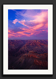
Gallery: 2007 / Grand Canyon and Lee's Ferry, AZ After heading back to Las Vegas and dropping Ted off for his flight home, I quickly left the zoo that is Las Vegas and drove right on through to the Grand Canyon South Rim, where I arrived just in time to witness a spectacular sunset. It was crazy busy there and I was lucky to snag a campsite right at the south rim to facilitate an easier sunrise photo session, which also turned out to be quite photogenic. Due to the vast numbers of tourists, I didn't stay there long and quickly headed over to Lee's Ferry, where there once was a steam-driven cable ferry crossing the Colorado River. Now, all that remains are a few old stone buildings, some debris at the river's edge and an old rusted steam boiler which is actually still in pretty good shape. |
|
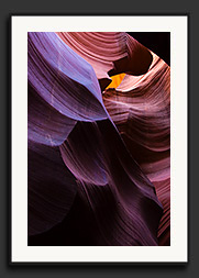
Gallery: 2007 / Horseshoe Bend & Antelope Canyon, AZ The next day brought a drive north to Page, Arizona, stopping off at for a view of the Horseshoe Bend in the Colorado River and finally Antelope Canyon (the south slots) for more great photo opportunities. The weather was very hot, apparently unseasonably so, and this after a major cold-snap that the southwest suffered through a few weeks earlier! Glad I hedged my bets and didn't only bring cold-weather clothing! Antelope Canyon is probably one of the most famous and most photographed slot canyons in the southwest. The entrance is just off a main road near the huge Navajo Power Station, and even though it is not a designated state or national park, there is an entrance fee which is collected by the local natives. Hiking down into Antelope Canyon is well worth the fee though, as it is truly a spectacular site to behold. Fast flowing water has carved a deep and convoluted chasm into the tan coloured sandstone. Hiking through the canyon can be challenging at times since it gets very narrow and angled but oh, what incredibly gorgeous light! The sunlight filtering down into the deeper parts of the canyon has a beautifully warm and diffuse quality because of all the scattering by the coloured sandstone walls and sometimes a small strip of blue sky above brings a bluish cast, turning the orange sandstone purple. |
|
Gallery: 2007 / Northern Arizona & Southern Utah The next few days were a zigzag of driving through northern Arizona and Southern Utah. First a long 280km detour brought me to Canyon De Chelly which, frankly, turned out to be a disappointment due to large numbers of tourists, garbage and bland mid-day weather. Then it was off to Monument Valley where the local quirky (and frustrating) sense of time -it's a long story- meant that I missed getting back in to a prime spot to view sunset. Argh. I then drove north and camped in Valley of the Gods and was rewarded with a spectacular sunrise. Later that day I drove onward to Natural Bridges National Monument in Utah for some strenuous hiking in the heat. |
|
Gallery: 2007 / Southeastern Utah The following day I hiked around a nondescript area of Glen Canyon at the north end of Lake Powell and managed to find some very nice views by just wandering around, and exploring off the beaten path. I very cooperative lizard decided to pose for a photo session as well! I then drove to an intriguingly named area, just east of the Henry Mountains, called the Little Egypt. What awaited were some spectacular goblin-like formations of red and tan coloured sandstone. I then drove north and took a detour along a rough 4x4 road through "The Squeeze" between the San Rafael Reef and the Shadscale Mesa near Green River and finally ended the day in Arches National Park, looking east to the La Sal Mountains over an area known as "The Petrified Dunes". Over the La Sal range were the impressive remnants of an evening thunderstorm. |
|
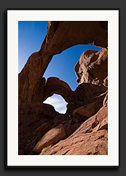
Gallery: 2007 / Arches and Canyonlands National Parks The next two days were spent on a whole bunch of hikes near the Double-Arch and Fiery Furnace areas of Arches National Park and a sunset at the Green River Overlook in Canyonlands National Park. I also managed a foiled attempt at catching sunrise under Mesa Arch in Canyonlands where the weather just did not cooperate... much to the dismay of all the photographers waiting there! I always visualized Mesa Arch as being much larger, but seeing all the other photographers next to it put it in perspective... That morning at Mesa Arch, I met up with Jon Fuller, founder of Moab Photo Tours. He is extremely knowledgeable about photographic locations in Utah, especially around the Moab area. Whether it is little-known native ruins, petroglyphs and pictographs or simply where the prime locations are for sunset and sunrise scenes, he seems to have a vast repository of knowledge in that respect. |
|
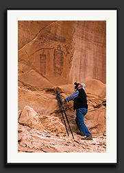
That same day, after the disappointing Mesa Arch hike, Jon and I continued on to several locations in Sevenmile Canyon where, GPS in hand, he flawlessly guided us to numerous locations with some impressive native rock art. Once the weather turned ugly and it started raining, we finished off that morning of photography by having lunch in Moab. Jon is a very friendly and easy-going guy and as I had mentioned, he really knows his stuff when it comes to when and where to be, to get the best photos around Moab. I highly recommend getting in touch with Moab Photo Tours if you are ever in the area and don't have a lot of time to go exploring on your own. I wish I had met Jon sooner as it would have saved me a whole lot of time over the years! But hey... I sure have enjoyed all the exploring I've done in Utah over the last 15 years. Plus, I even managed to surprise Jon with a few spots that even he didn't know of... |
And that (finally!) is the end of the photos from this trip. After lunch in Moab, it was a day and a half power-drive to get back home to Vancouver. Hope you've enjoyed the show!